Shaping Smarter Urban Environments Through Geospatial Digital Twins
In the relentless march of urbanization, our cities are constantly evolving. They are becoming more complex, more populous, and more interconnected. This transformation has led to a pressing need for innovative solutions to manage and improve urban life. Enter geospatial digital twins, a revolutionary technology that is poised to reshape our cities and make them more intelligent than ever before.
The Rise of Geospatial Digital Twins
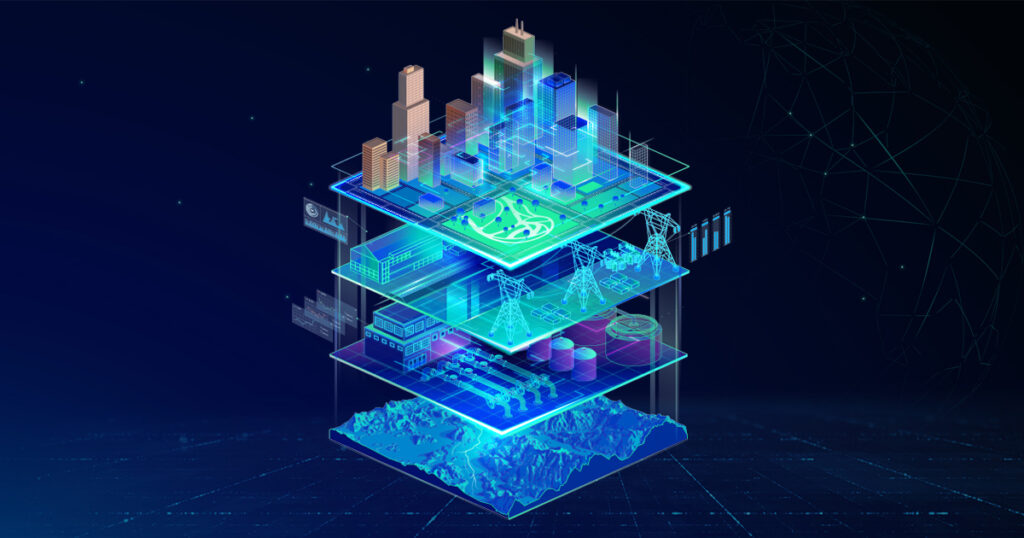
Digital twins are not a new concept, but their application in urban environments is a cutting-edge development. At their core, digital twins are virtual replicas of physical assets and environments. These digital counterparts use real-time data to provide insights, facilitate modeling, and support simulations. When it comes to urban environments, geospatial digital twins take this concept to a whole new level by integrating geographic information system (GIS) data, creating highly accurate and dynamic virtual city replicas.
Transforming Urban Environments
Enhanced Visibility
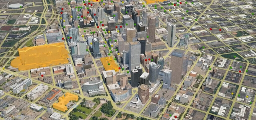
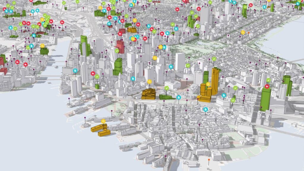
Imagine having a virtual “control center” for your city, where you can monitor everything from traffic patterns to crowd densities in real-time. Geospatial digital twins provide just that. They offer unparalleled visibility into the urban fabric by constantly updating with data from IoT sensors, cameras, drones, and more. This level of real-time awareness empowers city administrators to make informed decisions promptly, leading to improved safety and efficiency.
Smarter Modeling and Forecasting
One of the most significant advantages of digital twins is their ability to simulate and model various scenarios. Urban planners can use this capability to predict the impact of new projects and initiatives. For instance, they can analyze how new transit routes or changes to infrastructure will affect mobility patterns. This predictive modeling allows for more innovative, efficient urban planning, reducing costs and better resource allocation.
Optimized City Operations
Digital twins aren’t just for planning; they are invaluable for day-to-day operations. They help optimize energy and water systems, efficiently deploy emergency resources, and reroute real-time traffic. For example, Oslo’s digital twin is expected to reduce the city’s power consumption by 20% and lower water network energy usage by 40%. These are not trivial numbers; they represent significant strides toward sustainability and efficiency.
Collaboration and Engagement
Cities are complex ecosystems with multiple stakeholders, including city departments, citizens, academia, and the private sector. Geospatial digital twins serve as a shared platform for these stakeholders to collaborate effectively. Through detailed 3D visualization and interactive simulations, urban planners, policymakers, and citizens can come together to model scenarios, resolve issues, and ideate innovations. This promotes transparency and public-private partnerships, fostering smarter decision-making.
The Future of Smart Cities
The adoption of geospatial digital twin technology is on the rise. According to Gartner, by 2025, over 50% of public infrastructure organizations will use digital twins in some form, up from less than 5% in 2019. This statistic underscores the growing significance of this technology in shaping the future of smart cities.
With advancements in data acquisition, cloud analytics, and edge computing, digital twins are becoming smarter and faster. They are paving the way for responsive urban environments that adapt dynamically to ensure safety, efficiency, and livability in real-time.
The Road Ahead: Toward Responsive Urban Environments

The road to responsive urban environments paved by geospatial digital twins appears promising as we look ahead. While challenges such as data integration and talent development exist, the benefits far outweigh the hurdles. These digital twins offer a powerful tool for community stakeholders to visualize, understand, and improve city life collectively.
The next generation of innovative, sustainable cities will be built first in virtual environments to enhance the real. Geospatial digital twins offer a portal into this urban future now. City leaders around the globe are getting on board to realize the immense potential of this technology to drive positive transformation.
Leveraging Geospatial Digital Twins for Smart Cities
Improved Urban Planning
One of the most immediate and tangible benefits of geospatial digital twins is in urban planning. City planners can use these digital replicas to test different scenarios before implementing them in the physical world. For example, they can evaluate the impact of a new public transportation system, road network changes, or the addition of green spaces on the urban landscape. This saves time and resources and leads to more sustainable and citizen-friendly urban development.
Enhanced Infrastructure Management
Cities are home to vast infrastructure networks, from water and energy systems to transportation and telecommunications. Managing these systems efficiently is a constant challenge. Geospatial digital twins offer a solution by providing real-time data on the condition and performance of infrastructure assets. For instance, they can detect leaks in water pipelines, identify areas prone to traffic congestion, or monitor the structural health of bridges. This proactive approach to infrastructure management reduces maintenance costs, minimizes downtime, and enhances the overall quality of urban life.
Data-Driven Decision-Making
In an era where data is king, geospatial digital twins empower city leaders to make data-driven decisions. These digital replicas offer a comprehensive view of urban life by integrating data from various sources, including IoT sensors, satellites, and social media. This wealth of information can be harnessed to address pressing urban challenges. For instance, it can be used to optimize waste collection routes, allocate resources during emergencies, or develop strategies to combat air pollution. The result is a more responsive and resilient city that can adapt to the needs and preferences of its residents.
The Challenges and Opportunities

While geospatial digital twins hold immense promise, they are not without challenges. The most significant hurdles include:
Data Integration
Creating and maintaining a geospatial digital twin requires integrating data from a multitude of sources. This can be complex and time-consuming, as data formats and standards often vary. However, overcoming this challenge is crucial to harness the full potential of digital twins.
Talent Development
Effective utilization of geospatial digital twins requires a skilled workforce. Professionals who can work with GIS data, IoT technologies, and simulation tools are in high demand. Investing in talent development and education is essential to build the capabilities needed for future smart cities.
Privacy and Security
Collecting and analyzing vast amounts of data for digital twins raises concerns about privacy and security. City leaders must establish robust data protection measures and ensure that citizen data is used responsibly and ethically.
Take Away
Geospatial digital twins are ushering in a new era of smarter cities. These digital replicas are transforming how cities operate by providing real-time data, enhancing visibility, enabling modeling and forecasting, and fostering collaboration. As the adoption of digital twins continues to grow, we can look forward to more responsive and efficient urban environments.
If you’re interested in exploring the possibilities of geospatial digital twins for your city or organization, don’t hesitate to reach out to us at [email protected]


